Newcastle's topography tells a story of deep river gorges and steep valley sides carved through Carboniferous strata. With over 280,000 residents and a post-industrial landscape of former colliery workings and quarried slopes, the city presents unique geotechnical challenges. The River Tyne corridor alone exposes some of the steepest urban cuttings in the North East, where glacial till overlies sandstone and shale bedrock. In our experience, developers often underestimate how quickly a stable-looking bank can fail after heavy rainfall. We routinely combine test pits to map the till-bedrock interface with detailed limit equilibrium modelling to produce designs that stand up to both the British weather and the local geology.
We apply Spencer and Morgenstern-Price methods to model non-circular failures in Newcastle's glacial till, using site-specific triaxial data rather than conservative textbook parameters.
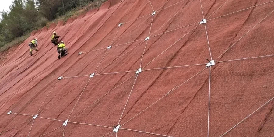
Scope of work in Newcastle
Critical ground factors in Newcastle
The contrast between two areas of Newcastle illustrates the risk: the dense boulder clay slopes in Jesmond Dene behave very differently from the weathered sandstone faces exposed along the Tyne at Scotswood. In Jesmond, the risk is shallow translational slides triggered by prolonged winter saturation. At Scotswood, the concern is often rockfall and wedge failure from joint-controlled blocks. A generic desktop assessment won't capture these differences. What we see most often in this region is that slope failures occur not during the construction phase, but three to five years later, after several freeze-thaw cycles and unmanaged vegetation growth have taken their toll. A solid slope stability analysis that accounts for long-term pore pressure equalisation and root reinforcement decay is the only reliable way to design for the service life of the asset, not just the construction period.
Our services
Our team delivers slope stability assessments that move beyond a simple factor of safety calculation. We provide practical recommendations that make sense for the site conditions, the construction programme, and the commercial realities of development in the North East.
Cutting and Embankment Analysis for Transport Infrastructure
We assess existing rail and highway earthworks against current Network Rail and National Highways standards, including long-term deterioration modelling and remediation design for cuttings in glacial till and Coal Measures mudstone.
Natural Slope and Development Platform Assessment
For residential and commercial developments on Newcastle's sloping sites, we evaluate global stability to satisfy building control requirements, often integrating the results with foundation design to optimise the building footprint relative to the slope crest.
Q&A
What factor of safety is required for a permanent slope in Newcastle?
For permanent slopes under BS EN 1997-1:2004, we typically target a minimum factor of safety of 1.3 to 1.5 against ultimate limit state failure, depending on the consequence class of the structure and the confidence level in the ground investigation data. For temporary works slopes with a design life under one year, a factor of 1.2 to 1.3 is generally acceptable, though we always discuss these values with the checking authority early in the design process.
How do you account for old mine workings in a slope stability assessment?
The Coal Authority reports form a mandatory part of any desk study in Newcastle. We integrate mine entry locations and shallow workings into our geological model. If workings are within a depth that could influence the slope's failure mechanism—typically within 10 times the seam thickness from the slope face—we include them as explicit voids or weakened zones in the numerical model and run sensitivity analyses to determine the worst credible scenario.
How much does a slope stability analysis cost for a typical housing development in Newcastle?
For a typical residential scheme on a sloping site in Newcastle, a full slope stability assessment including the ground model, limit equilibrium analysis, and a design report ranges from £880 to £3,750. The fee depends on the complexity of the geology, the number of critical sections requiring analysis, and whether we need to model remediation options such as soil nailing or regrading.
Do I need a slope stability analysis if my site has a gentle gradient?
Gradient alone is not a reliable indicator. We have assessed sites in Newcastle with slopes as shallow as 8 degrees where a combination of low-strength glacial till and elevated groundwater produced factors of safety below 1.0. The key drivers are the soil shear strength, pore water pressure, and the proximity of the proposed foundation loads to the slope crest. A Phase 1 desk study will flag whether a detailed analysis is warranted.