Newcastle’s post-industrial landscape conceals a complex stratigraphy that ranges from stiff glacial till to the fractured Coal Measures sandstone underlying much of the city centre. The River Tyne has carved a steep-sided valley through these deposits, leaving many development sites with abrupt changes in ground level and a high water table that responds quickly to North Sea tides. Monitoring excavation behaviour here is a matter of protecting Victorian-era infrastructure, adjacent listed buildings, and the Tyne and Wear Metro tunnels that thread beneath the urban core. We deploy automated total stations, in-place inclinometers, and piezometers to track wall deflection and groundwater drawdown, feeding data to a project dashboard that allows the design team to verify performance against the observational method outlined in Eurocode 7 (BS EN 1997-1:2004). When deep cuts expose the laminated clays of the Tyne Basin, the slope stability implications are assessed concurrently to ensure benched faces remain stable throughout the construction sequence.
Real-time monitoring transforms excavation risk from a retrospective argument into a proactive, data-driven management process.
Scope of work in Newcastle
Critical ground factors in Newcastle
The contrast between the dense boulder clay of Jesmond and the alluvial sands of the Quayside illustrates why a single monitoring specification cannot cover all of Newcastle. Jesmond’s stiff till can stand unsupported for short periods, but it masks sandstone pinnacles that concentrate stress on sheet pile interlocks, risking sudden leakage. Down on the Quayside, the loose river deposits and high tidal groundwater demand continuous dewatering, where a piezometer lag of even twenty minutes can mean the difference between a controlled drawdown and a blow-in at the toe of the excavation. We have seen projects where unmonitored party wall rotation exceeded 1:500 within a single weekend, triggering costly remedial underpinning. By instrumenting both the excavation support system and the surrounding ground, the team establishes an early-warning framework that catches these movements while they are still millimetric and reversible.
Our services
Our Newcastle excavation monitoring package is configured around the specific ground risks of the site and the sensitivity of surrounding assets, drawing on the techniques listed below.
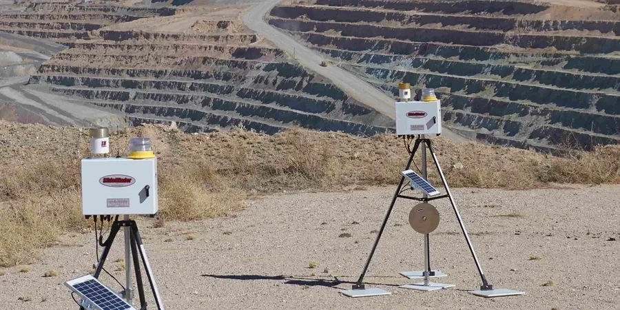
Wall Deflection & Inclinometry
In-place inclinometer strings installed inside soldier piles or diaphragm walls, logging tilt every 0.5 m of depth and transmitting data hourly. Combined with manual traversing probe checks for QA.
Vibration & Noise Monitoring
Triaxial geophones positioned on the nearest sensitive structure, with real-time alerts when peak particle velocity approaches 75% of the BS 7385-2 damage threshold.
Groundwater & Pore Pressure
Network of vibrating-wire piezometers and standpipes, read automatically via 4G data loggers. Used to calibrate the dewatering model and confirm the design drawdown radius.
Automated Optical Survey
Robotic total station tracking prisms on retaining walls, adjacent buildings, and road surfaces. Data is processed overnight and delivered as a displacement vector report by 07:00 the following morning.
Q&A
How much does excavation monitoring typically cost for a city-centre project in Newcastle?
For a typical basement excavation of 6–10 weeks in central Newcastle, monitoring packages generally range from £700 to £1,950, depending on the number of instrumented sections, the need for automated versus manual readouts, and the vibration sensitivity of neighbouring structures. A fixed-price proposal is issued after a site walkover.
Which Newcastle geology creates the most monitoring challenges?
The laminated clays and silts of the Tyne Basin are particularly demanding because they exhibit delayed pore-pressure response and can soften rapidly when exposed. Monitoring these deposits requires closely spaced piezometers and daily inclinometer readings, especially when excavation proceeds below the river level.
What is the observational method under Eurocode 7 and how is it applied?
The observational method (BS EN 1997-1:2004, Section 2.7) allows design to proceed with predefined contingency actions based on monitoring results. We establish trigger limits for wall deflection, groundwater level, and vibration, and if any limit is approached, the pre-agreed contingency — such as installing an additional prop — is activated without delaying the works.
How quickly can you deploy instruments if a site shows unexpected movement?
A rapid-response crew can install inclinometer casing, piezometers, and survey prisms within 24–48 hours of instruction. The data feed is configured the same day, so the design team receives actionable displacement trends before the next excavation cycle begins.
Does the monitoring system work alongside the principal contractor’s existing survey regime?
Yes. We typically integrate our data with the contractor’s project CDE using AGS4 or CSV formats, and our trigger alerts are copied to the site engineer and the temporary works designer. This avoids duplication and ensures all parties are working from a single source of truth.