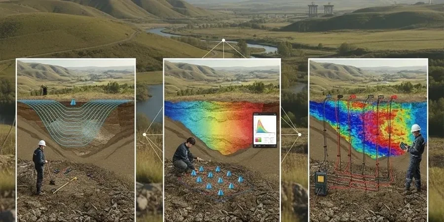
A warehouse extension on the north bank of the Tyne stalled last autumn because trial pits hit mixed fill over sandstone at unpredictable depths. The contractor had wasted three days. Our crew mobilised a 24-channel seismograph the next morning and ran parallel refraction and reflection profiles right across the site. Within 48 hours we delivered a contoured bedrock surface map that showed a buried channel filled with soft silty clay — the real reason trenches kept collapsing. In Newcastle, where coal measures, glacial till, and post-industrial backfill sit cheek by jowl with the Fell Sandstone, seismic tomography is the fastest way to resolve subsurface ambiguity without drilling a grid of boreholes. We run both P-wave refraction for rippability and SH-wave reflection for deeper structure, processing data with iterative inversion routines that honour BS 5930:2015+A1:2020 and the ground investigation requirements of Eurocode 7.
Velocity contrasts across the glacial till–sandstone interface in Newcastle routinely exceed 1000 m/s, giving us excellent refraction picks even in noisy urban settings.
Scope of work in Newcastle
Procedure video
Critical ground factors in Newcastle
Newcastle’s post-war clearance schemes filled dozens of denes and stream valleys with unrecorded material: demolition rubble, ash, slag from the old ironworks. These hidden features are a nightmare for shallow foundations and a genuine risk for borehole-only investigations that can miss them entirely. Seismic tomography reveals the lateral extent of these fills because their velocity signature is chaotic and distinctly lower than the surrounding till or bedrock. On slopes above the Tyne we have also mapped relic landslide blocks within the weathered sandstone mantle—features that a standard window-sample survey would never catch. The biggest liability we see in local projects is assuming uniform rockhead; the coal-measure cyclothems produce alternating competent sandstone and weak mudstone bands that seismic reflection can differentiate before excavation begins, reducing the chance of costly surprises during piling or basement construction.
Our services
Every seismic tomography job we run in Newcastle includes deliverables calibrated to the local geology. Our standard reporting package gives you more than a velocity section.
2D Refraction Tomography
P-wave profiling with 24 or 48 channels, processed through iterative inversion. Delivers a colour-contoured velocity cross-section with interpreted rockhead, weathering grades, and rippability classification according to BS 5930 excavation categories.
High-Resolution Reflection Profiling
SH-wave or P-wave common-midpoint stacks for imaging structure below 30 m. Ideal for mapping fault zones, coal seam continuity, and deep bedrock steps where refraction methods lose resolution.
Combined MASW-Seismic Package
Refraction spread used simultaneously for MASW acquisition, yielding both P-wave and S-wave velocity models. Provides Vs30 for seismic site class, small-strain stiffness for settlement analysis, and cross-validation between the two methods.
Q&A
Can seismic tomography work on a tight urban site in Newcastle with traffic noise?
Yes, and we do it regularly in the city centre. We use high-frequency geophones (10–28 Hz) and a vertical stacking routine that averages out random noise from traffic and machinery. On extremely noisy sites we run the survey at night or on Sunday mornings. The key is the velocity contrast: the glacial till–sandstone boundary in Newcastle produces such a strong refraction that the first breaks remain pickable even with moderate background noise.
How deep can seismic refraction realistically see in Newcastle’s geology?
With a 115-metre spread and an accelerated weight-drop source, we routinely image to 30–35 metres in the Tyne Valley. On the higher sandstone ridges where the rock is shallower and drier, the practical limit is closer to 25 metres. For depths beyond 40 metres we switch to seismic reflection or recommend supplementary borehole investigation. The governing factor is not the instrument but the spread length: rule of thumb is penetration equals roughly one-quarter of the spread.
Do you need access on both sides of the site for a seismic line?
Not necessarily. We can shoot end-on or use off-end shots if we can access only one side. The tomographic inversion handles asymmetric ray coverage well. For reflection surveys, split-spread geometry is ideal, but we have processed single-ended spreads successfully on constrained sites along the Quayside where buildings block one end.
What does a seismic tomography survey cost for a typical Newcastle site?
For a standard single-line refraction survey of 69–115 metres with 24 geophones, our fees range from £2,410 to £4,630 depending on access conditions, source type, and the level of interpretation required. A combined refraction-plus-MASW survey or a multi-line site falls toward the upper end. We provide a fixed-price quote after a site walkover, which we do at no charge within the Newcastle city boundary. More info.