Newcastle's geology, dominated by Pennine Middle Coal Measures with thick glacial till deposits across the Team Valley and steep sandstone outcrops along the Tyne Gorge, demands a measured approach to seismic site characterisation. The MASW (Multichannel Analysis of Surface Waves) method provides a non-invasive way to determine the average shear wave velocity of the upper 30 metres (VS30), a parameter that directly feeds into Eurocode 8 site classification and foundation design. In a city where Victorian-era structures sit atop mined seams and modern riverside developments rise on alluvial soils, the contrast in dynamic stiffness between the Fell Sandstone and the soft clays of the Ouseburn basin can be stark, making accurate VS30 profiling essential. When we deploy a 24-channel geophone array on a brownfield site in Scotswood or a tight urban plot in Jesmond, we are mapping the subsurface's response to dynamic loading before a single pile is driven. The resulting shear wave velocity profile integrates with deeper investigations like seismic refraction to resolve bedrock geometry or with liquefaction assessments when silty sands are encountered near the quayside.
In Newcastle, the difference between a Site Class C and a Site Class D can hinge on just three metres of buried fill — MASW gives us the resolution to make that call with confidence.
Scope of work in Newcastle
Procedure video
Critical ground factors in Newcastle
Newcastle's post-industrial landscape carries a legacy that directly influences seismic hazard assessment. The city expanded rapidly during the 19th century, with mining beneath what are now residential districts like Heaton and Byker — areas where shallow workings and backfilled shafts create artificial velocity anomalies that can skew a naive VS30 interpretation. A site classified as Class C on paper may behave locally as Class D if an undocumented drift mine runs beneath it at 15 metres depth. Our surveys incorporate a careful review of Coal Authority mining reports alongside the geophysical data, because a sudden velocity inversion in the top 30 metres is often a tell-tale sign of unconsolidated backfill rather than natural stratigraphy. The risk of misclassifying a site class is not theoretical: we have seen projects where an overly optimistic VS30 value led to an under-designed foundation, requiring costly remediation when ground truth emerged during excavation. Complementing MASW with targeted test pits in suspect zones helps ground-truth the near-surface materials and refine the velocity model before it reaches the structural engineer's desk.
Our services
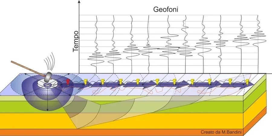
Our MASW surveys in Newcastle are designed to deliver the seismic site class and shear wave velocity data required by structural engineers and local authority building control. Each survey is tailored to the site's specific ground conditions and access constraints.
VS30 Site Classification Surveys
Active-source MASW with 24-channel geophone array to determine the average shear wave velocity in the upper 30 metres. We provide a signed report with the 1D Vs profile, VS30 value, and the corresponding Seismic Site Class (A through E) per BS EN 1998-1, suitable for submission with a Building Warrant or planning application.
Combined MASW & Seismic Refraction Profiling
For sites with complex bedrock topography — common along the Tyne Valley and in the former mining districts of West Newcastle — we combine MASW with seismic refraction to simultaneously map the P-wave velocity structure and the shear wave velocity profile, resolving both the overburden thickness and the dynamic stiffness of the rockhead in a single deployment.
Q&A
What does a MASW survey in Newcastle typically cost?
For a standard active-source MASW survey at a residential or commercial plot within the Newcastle area, budgets usually fall between £1,210 and £2,850 plus VAT. The final figure depends on the array length needed to reach 30 metres, the number of shot points, and whether passive-source recording is required for deeper penetration. We provide a fixed-price proposal after reviewing the site location and the Coal Authority mining report.
Which Seismic Site Class is most common in Newcastle?
There is no single answer — Newcastle's geology varies sharply. Sites on the Fell Sandstone in areas like Heaton or Jesmond often classify as Site Class B, while the thick glacial till in Gosforth and the alluvial deposits along the Ouseburn and Tyne quayside typically fall into Class C or D. The key is the shear wave velocity of the weakest 30-metre interval, and we have measured VS30 values ranging from 180 m/s in soft river silts to over 700 m/s in competent sandstone.
How long does a MASW survey take on site, and will it disturb neighbours?
A typical active-source MASW survey across a single array takes two to four hours on site, depending on ground conditions and access. The source is a sledgehammer striking an aluminium plate, which generates a surface thud — noticeably quieter than percussive drilling or dynamic compaction. In dense urban settings like Sandyford or Fenham, we brief adjacent residents in advance and position the array to minimise nuisance, and the equipment is removed the same day.